This article highlights the unseen dangers from park trees. Arborists can inspect trees, but it's impossible to see every possible hazard. For students studying urban tree care this article shows how important their work is!
Sunday, June 27, 2010
Fatal Accident at Central Park Puts Focus on Trees - NYTimes.com
Fatal Accident at Central Park Puts Focus on Trees - NYTimes.com
Thursday, June 24, 2010
New Topographic Map Formats
While looking for a map on the US Geological Survey site today I found a new format of topographic maps. Previously it was easy to download a scanned topographic map in pdf format. Today I noticed that for some regions there is a new kind of map called a US Topo. It has a true color aerial photo for a base with all the usual topographic map features on top.
 Following is the June 2010 version of the same area.
 For some maps there is a Digital Maps beta version that doesn't yet have the contour lines. The new maps can be purchased in paper format. Even better is the pdf format. The data in the new maps can be separated in the reader, just like in a GIS. When you install the free TerraGo add-on in Adobe Reader you can make measurements of direction and distance directly on the map. Very Cool! It is all available at http://store.usgs.gov Topographic maps will never be the same again!
For example, below is a part of the Iron Springs 7.5 minute map showing the Waynesboro Reservoir, which was made in 1995.
Monday, June 21, 2010
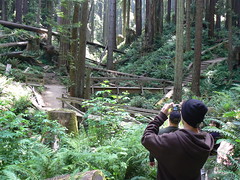
Visit to Redwood Country

Originally uploaded by P_Linehan.
A group of Penn State Mont Alto forestry students and faculty recently visited the redwood forests in Humboldt County, California. Seen here during a tour of Humboldt University's Schatz Demonstration Tree Farm, led by manager Gordon Schatz, are students Mitch Oswald and Zach Hetrick, faculty Craig Houghton, Beth Brantley and Peter Linehan, and students Tyler Wakefield, and Nate Rosenberg. The students have each participated in forestry research projects funded by Schatz research fund grants.During the visit from June 11 to 15 the group visited the Avenue of the Giants in Humboldt Redwood State Park with its groves of amazing trees.
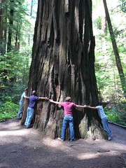
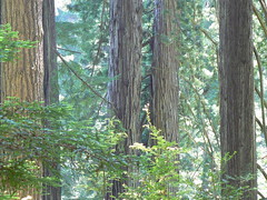
The tour also included parts of Redwood State Park, the Arcata Community Forest, and the Humboldt Lagoons State Park, among other places. Everyone learned a great deal about the life cycle and ecology of the amazing redwoods!
Thanks to Schatz family for funding student travel for this trip. Also, many thanks to Gordon and Karen Schatz for their time and excellent company! To see more pictures click here. See a map of the visit here.
Tuesday, June 01, 2010
Graduation 2010
Graduation at Penn State Mont Alto was held on May 15. Below are the forest technology graduates. ( A few were missing).
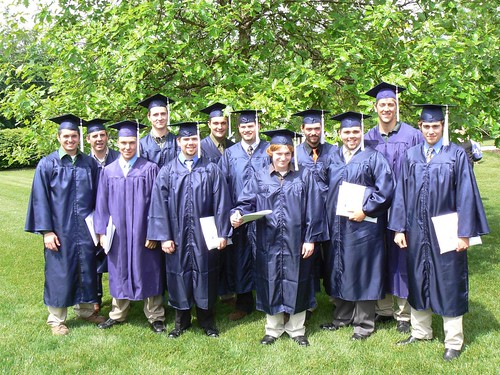
It's always nice when forest technology alumni return to Mont Alto. Flanked by Dr. Brantley and Mr. Houghton; Andrew Baker, Chance Yeakly, and Tiffany Roddy from the class of 2008, received their B.S. in forestry diplomas at Mont Alto's graduation ceremony.

It's always nice when forest technology alumni return to Mont Alto. Flanked by Dr. Brantley and Mr. Houghton; Andrew Baker, Chance Yeakly, and Tiffany Roddy from the class of 2008, received their B.S. in forestry diplomas at Mont Alto's graduation ceremony.
End of Selective Availability Anniversary
The June 2010 issue of Forestry Source (subscription required) contains a short primer on GPS. Author Steve Wilent mentioned the tenth anniversary of the end of Selective Availability (SA) on May 1, 2000, following an executive order by President Clinton. Under the SA program deliberate error was introduced into the GPS signal so that the live signal would have an error of about 100 meters. This was done to protect national security during military operations. Only military GPS receivers had a chip to remove the error.
The policy was changed to promote the use of GPS in the general economy. The military agreed fully with the new policy. There were ways around SA, by using a supplemental FM correction signal broadcast locally by the US Coast Guard or by doing post-processing correction of field data in the office.
Now that the GPS signals has no more deliberately introduced error the use of GPS has grown dramatically in all parts of the economy from cars to personal devices. The sport of geocaching would not be possible if SA were still in operation.
For foresters, the end of SA has meant that low cost, rugged, recreational grade GPS receivers can be used for most forestry operations. The accuracy of these receivers is more than enough for most forestry mapping operations. The forest technology program at Penn State Mont Alto has been able to acquire sufficient receivers so that all the students can have one to use for field work. Collecting GPS data in the field and using it to create maps has now become a normal part of all fieldwork.
We should make the end of SA a national holiday!
Subscribe to:
Posts (Atom)